
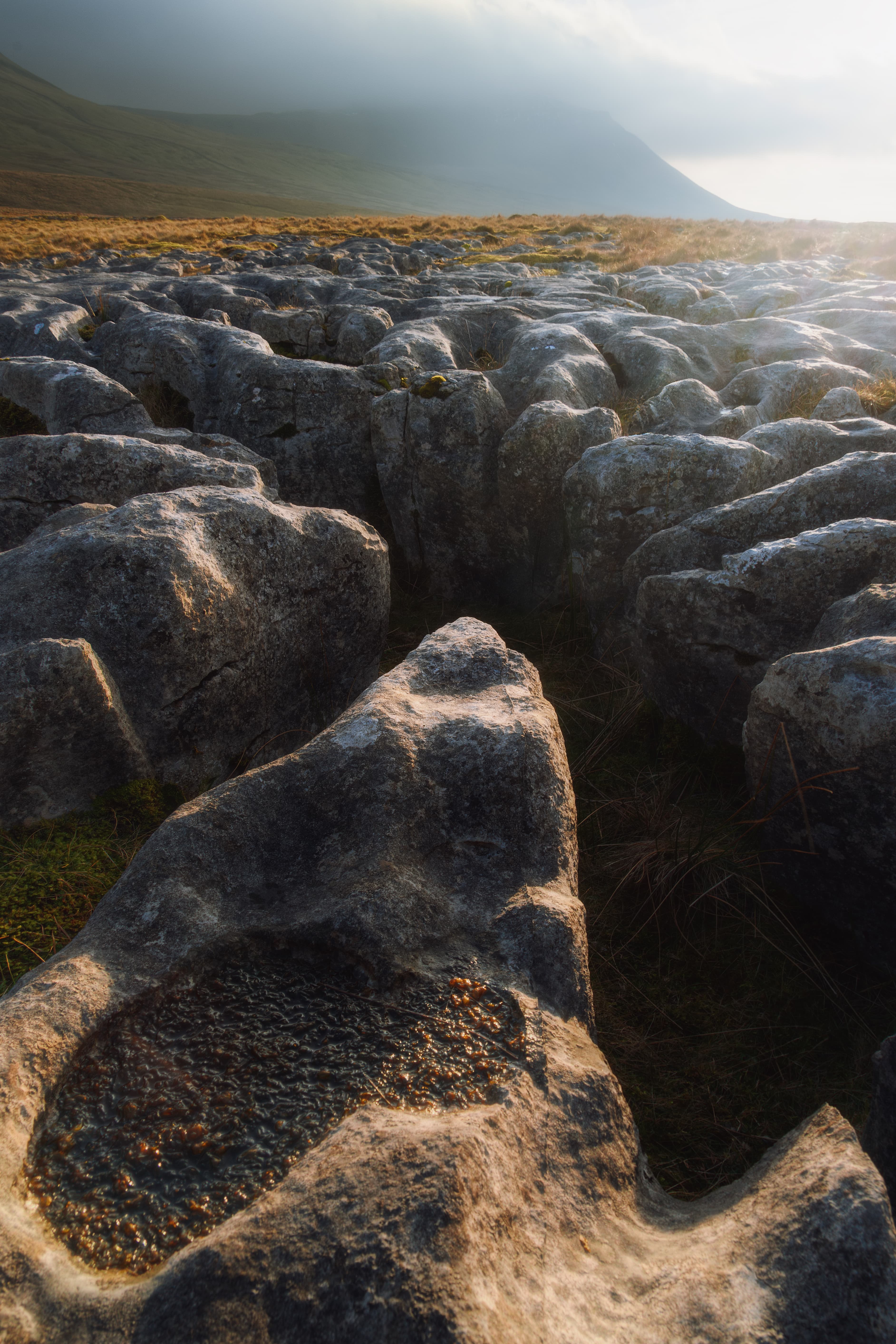
Southerscales Scar, Yorkshire Dales, England.
Rules:
1.. Please mark original photos with [OC] in the title if you're the photographer
2..Pictures containing a politician from any country or planet are prohibited, this is a community voted on rule.
3.. Image must be a photograph, no AI or digital art.
4.. No NSFW/Cosplay/Spam/Trolling images.
5.. Be civil. No racism or bigotry.
Photo of the Week Rule(s):
1.. On Fridays, the most upvoted original, marked [OC], photo posted between Friday and Thursday will be the next week's banner and featured photo.
2.. The weekly photos will be saved for an end of the year run off.
Instance-wide rules always apply. https://mastodon.world/about
Southerscales Scar, Yorkshire Dales, England.
Reminds me of Death Stranding a bit.
Limestone pavement is made up of clints (the blocks) and grykes (the fissures or cracks in between). If you peer into the grykes, you’ll discover a rich, hidden world of plants, such as baneberry, green spleenwort, lesser meadow-rue, wood sorrel and herb Robert. The site is rich in ferns, including rigid buckler and hart’s-tongue. https://www.ywt.org.uk/nature-reserves/southerscales-nature-reserve
The geology of the Yorkshire Dales is predominantly of limestone, which gives rise to many spectacular and scenic surface (as well as underground) natural features. One such type of surface feature are the "limestone pavements" - plateaus of bare and weathered rock often being found at the top of the limestone cliffs (known locally as "scars") running along the hillsides. These were originally formed by the scouring action of glaciers during the last ice age, excellent examples being seen at e.g. the top of Malham Cove, White Scars and Southerscales (near Ingleton) and on the plateau of Moughton (near Austwick).
Due to the mildly corrosive effects of slightly acidic rain water on the limestone (a process which also leads to the formation of caves and potholes in the dales) deep crevases slowly develop in the rock so that the limestone pavements are actually a "mosaic" of interlocking "clints" and "grykes" https://www.yorkshire-dales.com/limestone-pavements.html
Pffsshh. Get out of here with your made up words and places!
I kid, it's amazing 😁
Hah, well this area is the land of caves and potholes, where there's all sorts of weird and wonderful names.
And loads more.
It's like a field of molar teeth.
I like this imagery.
I thought you were talking about some English gangs that met in a field.
Beautiful image, that's amazing
Thank you!
That’s the earth’s wrinkly brain showing through.
God's own country.
Stromatocytes?