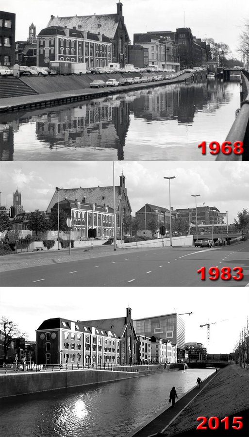
Here's a before-and-after-and-after of the Catharijnesingel by @[email protected] (from X, which I won't link to).

A laid back community for good news, pictures and general discussions among people living in Europe.
Other European communities
Other casual communities:
Language communities
Cities
Countries
Here's a before-and-after-and-after of the Catharijnesingel by @[email protected] (from X, which I won't link to).

Now I understand! So the canal was covered up with a highway, water was just going beneath it (Edit: I read it appears to have been drained when the highway was constructed). Removing the highway just uncapped it again.
I can't believe someone would ctually do this, so awesome!
they just ctrl z
Cool comparison, but it's worth pointing out that the second picture is taken from the bridge that you can see in the first picture. So those big buildings you see on the left in the first picture didn't just disappear, they're just moved out of the shot.
I don't think the problem are the buildings but the car infrastructure.
That's why I said it's still a cool comparison. But cropping out the buildings and focusing more on the trees exaggerates the change a bit and makes it seem as if the entire area has been given back to the wilderness.
It must be great living in a sane country.
Found it on maps: https://maps.app.goo.gl/ivjnRK76Zgk9fnce7?g_st=ac
Adding to this.
Mapillary has a load of different perspective on the canal as well. The same bridge/canal but on OpenStreetMap.
Did they really build a fucking street on top of the river? Why would you do this?
In 1973 they replaced the canal with a road, since... cars go vroom vroom and need space, but this was reverted between 2010-2020.
need space
Press X to Doubt
Fuck cars.
More like crave and devour space like a cancerous growth
Pretty much, yes - the Stadsbuitengracht was a defensive moat originally, then they converted part of it into a motorway in the 70s.
Not uncommon. Cities grew and the aqueducts just went director to their river, si they suck and paving them was a good excuse to get rid of the sanitation problems they had while expanding car infrastructure. Cities today know better and built aqueducts that didn't dump everything to the river.
Was in Bayreuth a couple of weeks ago - they had pictures of the city centre 40-50 years ago hanging there. Couldn't find the exact image on the internet but here is a postcard from around that time. This is how it looks today (you can see the fountain and the house with the steep roof on both images)
Beautiful!
That's literally unbelievable
The paradox that arises from the tension between the literal truth of something and the disbelief it inspires compels me to contemplate the consequences of having to wonder what yesterday's prediction about tomorrow will be.