26
Map Enthusiasts
2976 readers
2 users here now
For the map enthused!
Rules:
-
post relevant content: interesting, informative, and/or pretty maps
-
be nice
founded 1 year ago
MODERATORS
27
216
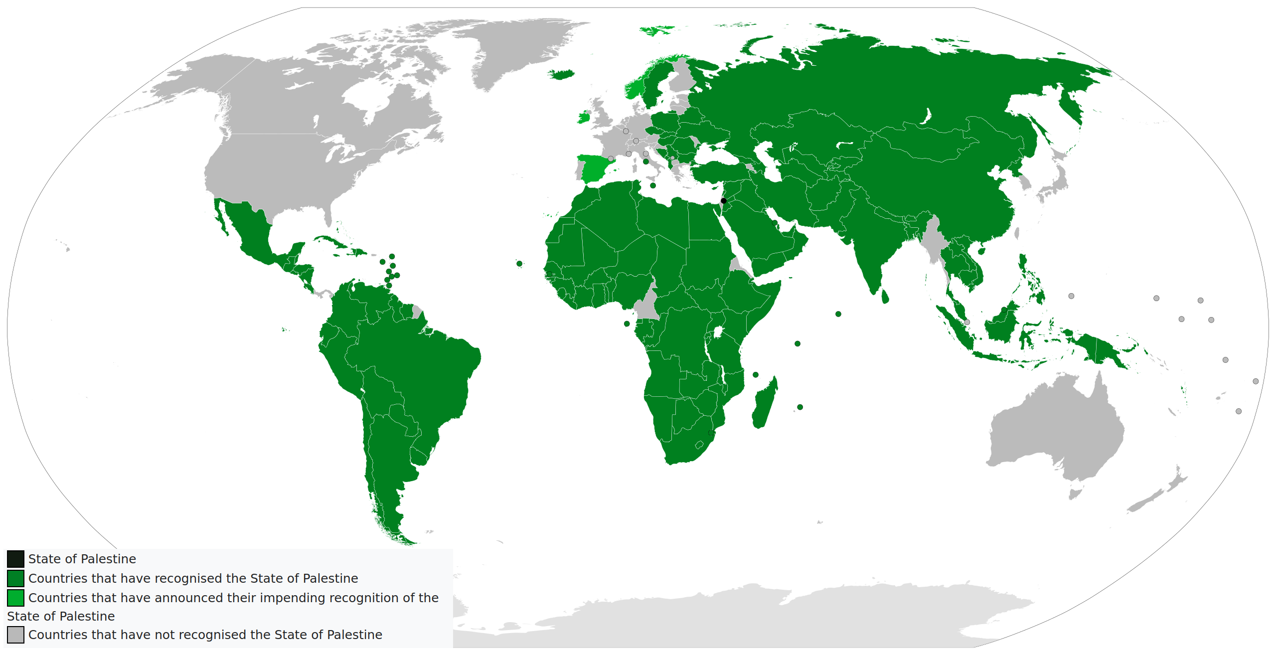
International recognition of Palestine, with today's latest additions of Ireland, Norway and Spain
(images2.imgbox.com)
28
From a gazetteer called 瀛環志略 'A Short Account of the Maritime Circuit' by Chinese official Xü Jiyu in 1849.
Unfortunately out of all the maps in the book, France suffered the most mistakes with several names being misplaced which makes this a nightmare to translate. I'll leave it for u guys to point out the mistake.
The Chinese seemed to have a more positive view of the French compared to the British-
"Among the countries of Europe, France (佛朗西) boasts the longest-lasting legacy. Since the time of Charlemagne's reign, it has endured for over a thousand years.
Despite enduring various upheavals, its rulers have consistently emerged from its own faction, avoiding the establishment of foreign dynasties or female monarchs, a departure from the practices of other nations. Its legal system is robust, producing capable rulers every six or seven generations, enabling it to navigate crises without succumbing to downfall, suggesting a certain underlying stability.
Regarded as the foremost martial power in Europe, France consistently strives for supremacy, refusing to be outdone by others. Any affront is met with a steadfast determination for retribution. Its people are characterized by their generosity and readiness for battle, embodying a martial spirit reminiscent of ironclad horses.
Unlike other nations, France conducts its military affairs with a sense of justice rather than solely pursuing profit. Thus, despite enduring numerous internal and external challenges over the course of a millennium, France maintains its vigilance over the Western world, its national strength remaining unshaken. Even the celebrated victories of Napoleon ultimately led to his defeat, serving as a cautionary tale against unchecked military ambition.
France also possesses several overseas territories, including Pondicherry in South India, Guiana in South America, Algeria in North Africa, and Reunion Island in the Indian Ocean. However, these territories are neither extensively developed nor particularly cherished, as they are not deemed vital to France's interests.
Like other European nations, France engages in maritime trade, with ships from England, America, and Spain making annual voyages to China. These ships carry a variety of goods, including cotton, cloth, rice, pepper, sandalwood, and sea cucumbers, primarily sourced from Southeast Asia rather than France itself.
However, French merchant ships are relatively few in number, typically ranging from three to four, sometimes even fewer. Their imports mainly consist of luxury items such as feathers, clocks, watches, and other precious goods, showcasing France's wealth and craftsmanship. Wine, clay, silk, and similar commodities sold to other European nations yield profits tenfold without the need for extensive voyages.
France's maritime expeditions to the East are driven more by a desire for prestige than mere economic gain, reflecting its unique national strength and aspirations."


30
161
EU states signing declaration committing to legal equality, protection, national strategies and work for social acceptance of LGBTIQ people
(files.catbox.moe)


36
46
Mother's Day around the world (for people in Spain and Portugal, it's today)
(www.officeholidays.com)

37
Viceroyalty of New Spain (1521-1821) comprising five royal audiencias and over twelve Catholic dioceses covering vast and diverse territories that included present-day Mexico, Central America, Cuba, Santo Domingo, Puerto Rico, Florida, the Midwest and Southwest of the United States, California, and the Philippines.
Insightful comment:
Small correction, "San Miguel" on Vancouver Island, ie, Yuquot on Nootka Sound, being marked 1795 isn't right if the date is supposed to be when it was established. The outpost and fort at Nootka Sound was abandoned for good in 1795. It was first built in 1789.
The Nootka Crisis took place there in 1789, leading to three diplomatic agreements between Spain and the UK, averting war. The third agreement, titled "Convention for the Mutual Abandonment of Nootka", was signed in January 1794. The agreement involved naval officers meeting there to conduct a official ceremony, per the agreement.
Because it was so far from Europe it took over a year to actually do it. Still, on March 28, 1795, officials met at Nootka Sound and did a odd little ceremony, raising and lowering flags. Then the outpost and fort were dismantled for good.
Also, Russian American was not yet defined as the shape of present day Alaska state until the 1820s. In 1800 Russia was still fighting the Tlingit for control of Sitka Sound. It wasn't until the 1804 Battle of Sitka that the Tlingit left the Sitka area, letting the Russians control the west side of Baranof Island. Russia definitely did not control the rest of southeast Alaska until later.
Finally, that far north area labeled "unexplored" was partially explored by 1800. Alexander Mackenzie traveled the river named for him to the Arctic Ocean in 1789, for example.
Oop, and one more—wow the mapmaker put Monterey, California, in a totally incorrect place. And spelled it wrong too. Monterrey is the one in Mexico.

38


46


