paulhammond5155

joined 1 year ago
 

Curiosity Rover - Sols 4359-4361: The Perfect Road Trip Destination For Any Rover! Earth planning date: Friday November 8, 2024.

After the excitement of Wednesday’s plan, it was a relief to come in today to hear that the drive toward our exit from Gediz Vallis completed successfully and that we weren’t perched on any rocks or in any other precarious position. This made for a very smooth planning morning, which is always nice on a Friday after a long week.

But that isn’t to say that Curiosity will be taking it easy for the weekend. Smooth planning means we have lots of time to pack in as much science as we can fit. Today, this meant that the geology group (GEO) got to name eight new targets, and the environmental group (ENV) got to spend some extra time contemplating the atmosphere. Reading through the list of target names from GEO felt a bit like reading a travel guide — top rocks to visit when you’re exiting Gediz Vallis!

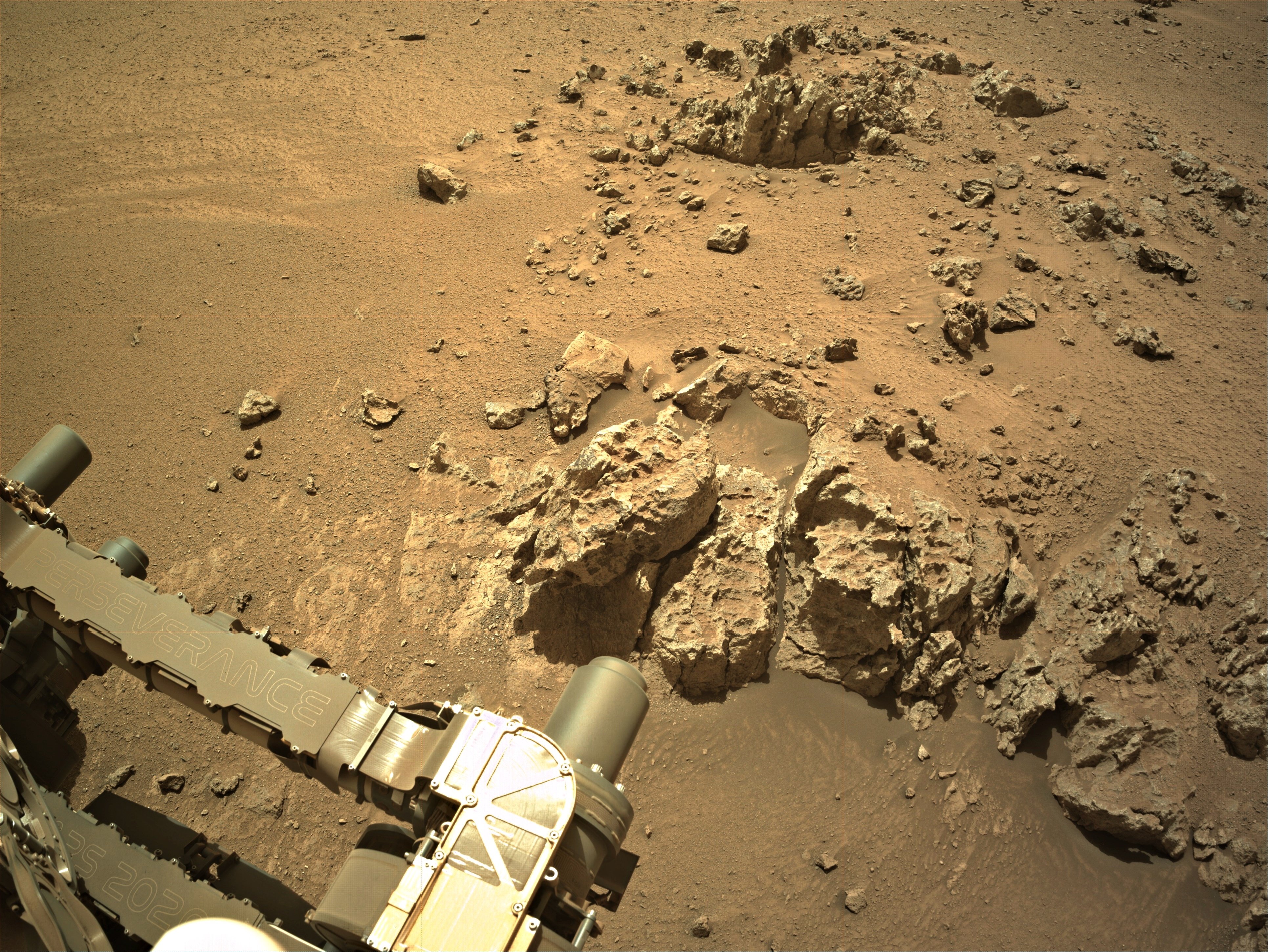
If you look to the front of your rover, what we refer to as the “workspace” (and which you can see part of in the image above), you’ll see an array of rocks. Take in the polygonal fractures of “Colosseum Mountain” and be amazed by the structures of “Tyndall Creek” and “Cascade Valley.” Get up close and personal with our contact science targets, “Mahogany Creek,” “Forester Pass,” and “Buttress Tree.” Our workspace has something for everyone, including the laser spectrometers in the family, who will find plenty to explore with “Filly Lake” and “Crater Mountain.” We have old favorites too, like the upper Gediz Vallis Ridge and the Texoli outcrop.

After a busy day sightseeing, why not kick back with ENV and take a deep breath? APXS and ChemCam have you covered, watching the changing atmospheric composition. Look up with Navcam and you may see clouds drifting by, or spend some time looking for dust devils in the distance. Want to check the weather before planning your road trip? Our weather station REMS works around the clock, and Mastcam and Navcam are both keeping an eye on how dusty the crater is.

All good vacations must come to an end, but know that when it’s time to drive away there will be many more thrilling sights to come!

Written by Alex Innanen, Atmospheric Scientist at York University

Source for this blog and the archive of all blogs (with all the links and the original raw images etc) https://science.nasa.gov/blog/sols-4359-4361-the-perfect-road-trip-destination-for-any-rover/

These blog updates are provided by self-selected Mars Science Laboratory mission team members who love to share what Curiosity is doing with the public.

Dates of planned rover activities described in these reports are subject to change due to a variety of factors related to the Martian environment, communication relays and rover status.

Image credits: NASA/JPL-Caltech


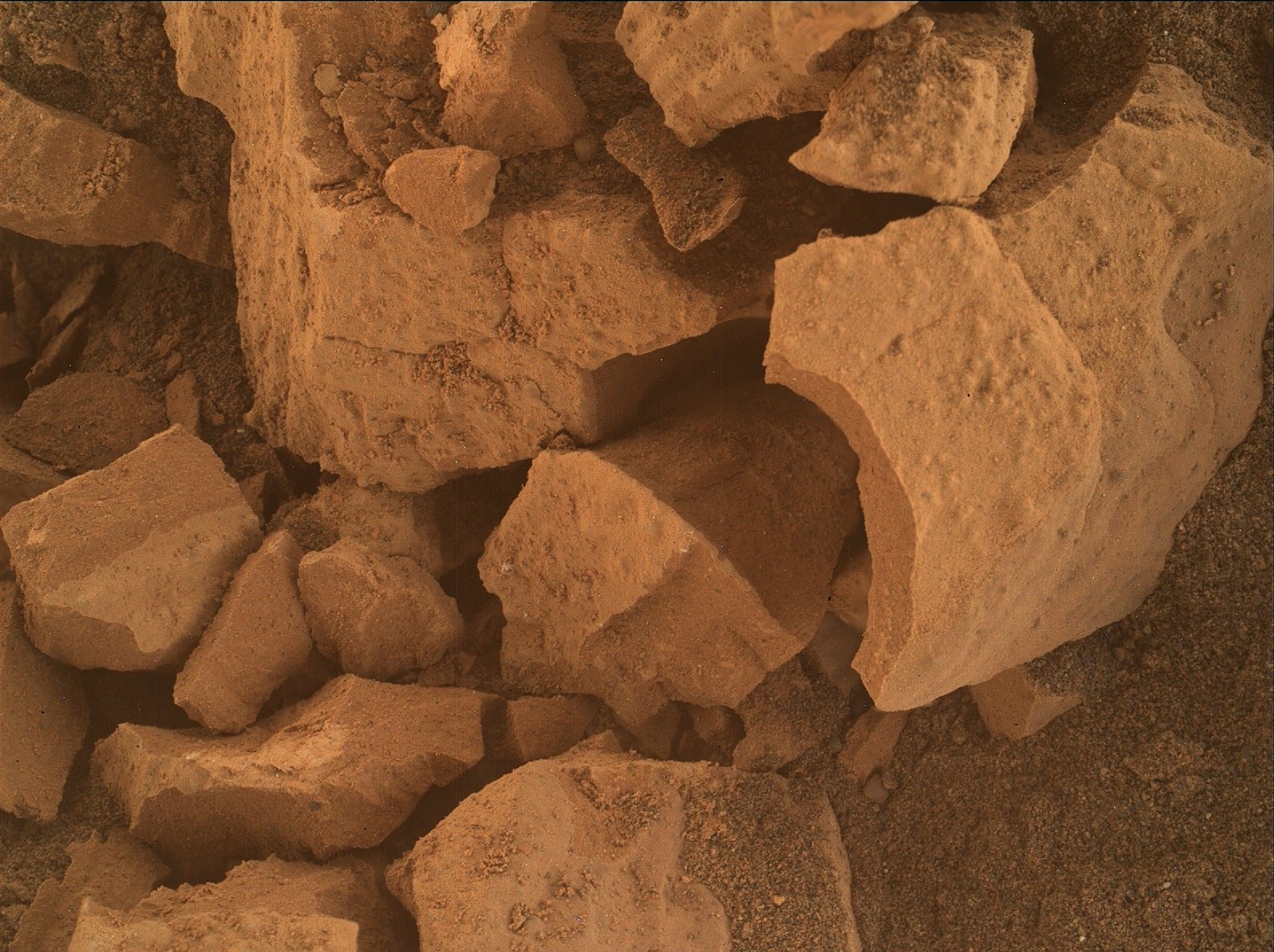
Curiosity assembled this focus stacked product using images from its Mars Hand Lens Imager (MAHLI), located on the turret at the end of the rover's robotic arm, on November 11, 2024, Sol 4360. The base images were acquired one sol earlier (4359). The camera focus motor count returned with the first image has been used to estimate the camera standoff distance (camera lens to the target). In this case the standoff was ~25 centimeters (~10 inches). That standoff provides an image scale of ~95 micrometers per image pixel, or a scene width of ~15 centimeters (~6 inches). Image Credits: NASA/JPL-Caltech/MSSS.


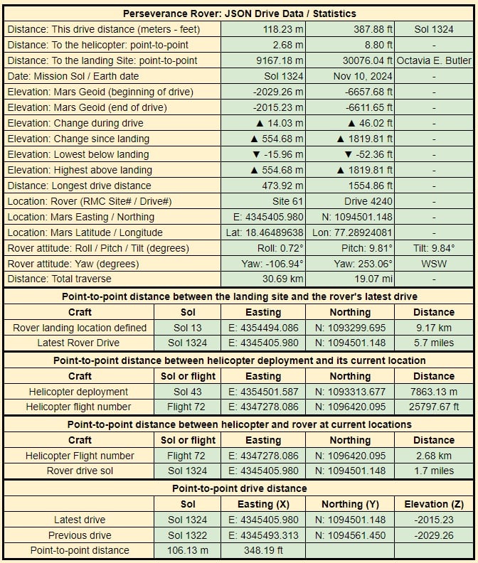
Data taken from JPL's JSON feeds.

The JSON details are updated by JPL shortly after each drive


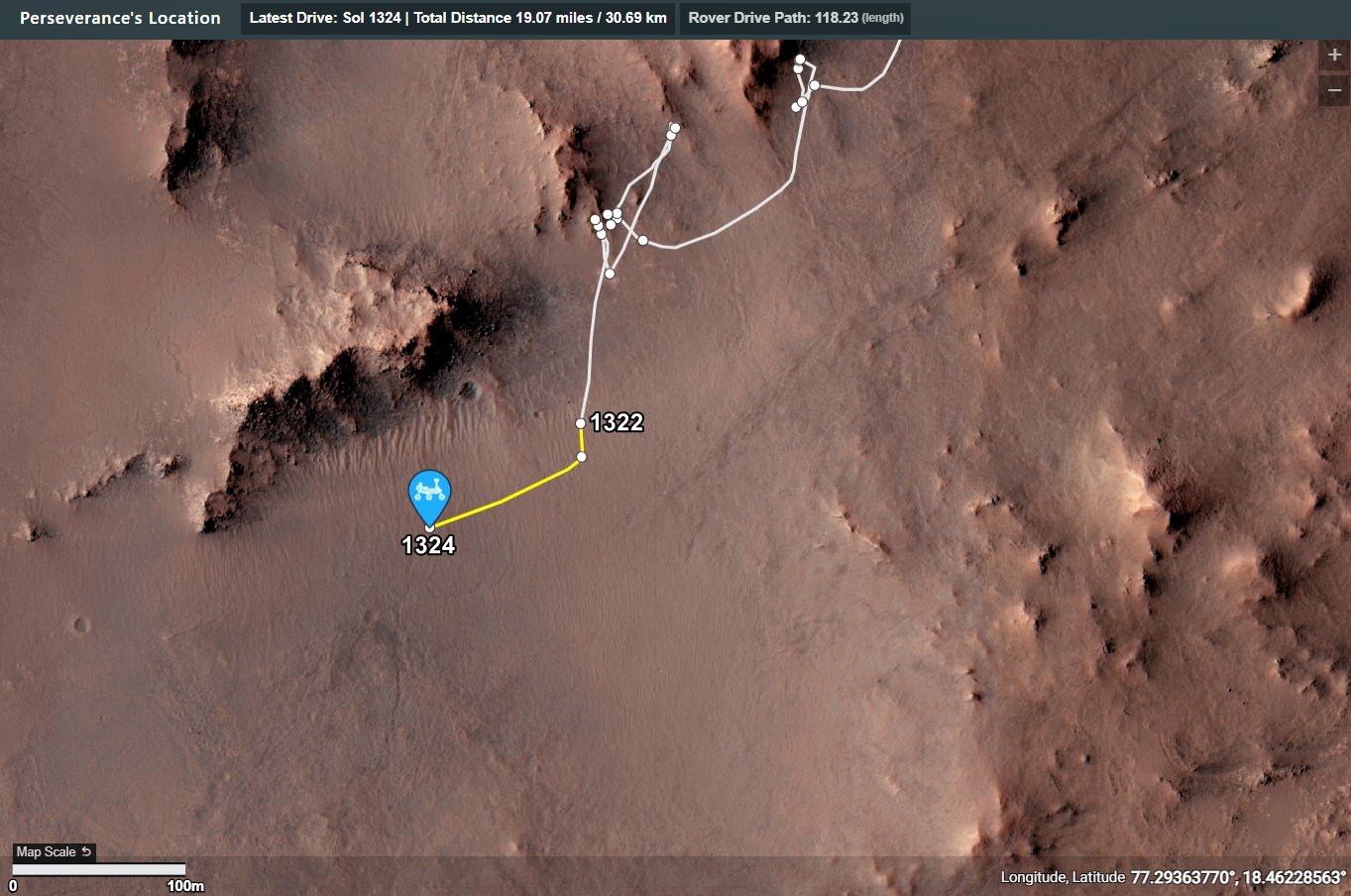
This is just an annotated screen capture

Visit the on-line map


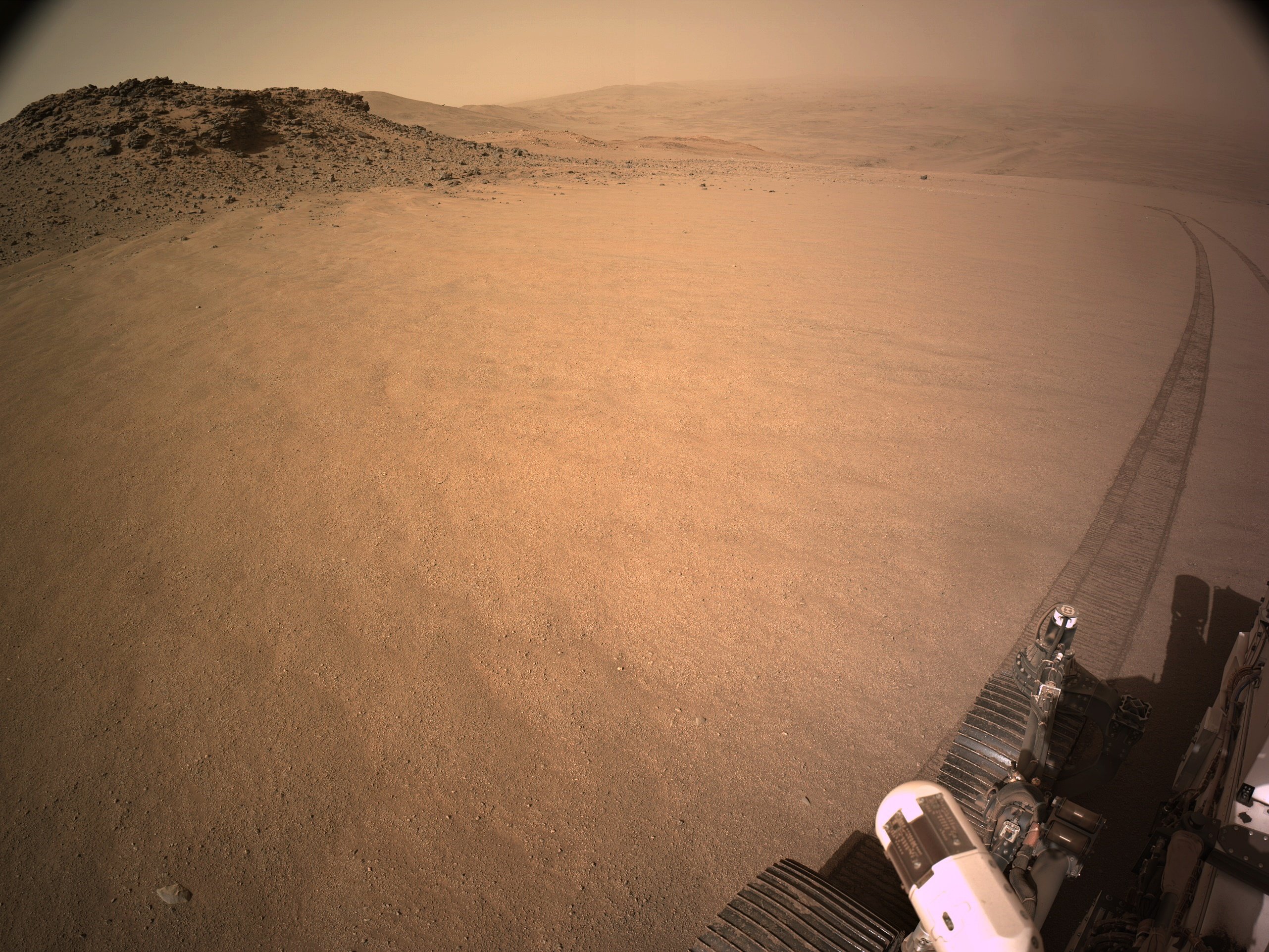
End-of-drive NavCam from site 61.4240. Map and drive details will follow once JL release the formal data. NASA/JPL-Caltech

EDIT: Corrected an error in the estimated elevation change


NASA/JPL-Caltech


Credits: NASA/JPL-Caltech/ASU/MSSS


Pick a rock, any rock 😜

9-tile end-of-drive R-NavCam.

Site 61.2782

No details of the official distance yet, but it's just a few meters, I'll post the drive details and updated map asap

NASA/JPL-Caltech


Extract from the Blog....

A MAHLI-only target of a crushed rock we drove over named “Milly’s Foot Path.”


Data is extracted from JPL's JSON files that are updated after each drive


The drive on 1320 is highlighted with a yellow path.

The small white circles are waypoints


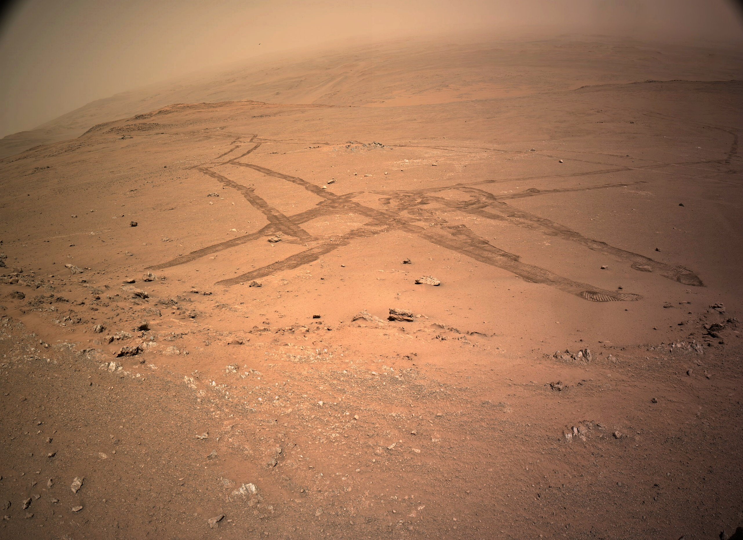
The rover's tracks in this image show us its complex journey exploring this section of its climb out of the crater. This end-of-drive post-drive tiled NavCam was acquired after a drive on November 6, 2024 (Sol 1320) of ~29 meters / ~95 ft to the north, arriving on the oposite side of a small ridge the rover explored several sols ago. Credits: NASA/JPL-Caltech

[–] paulhammond5155 3 points 1 month ago

The rover is currently driving up the rim wall of Jezero crater. The rim wall was created by a huge impact in Mars early history. So we could be looking at some of the oldest rocks that were uplifted during the impact. I'm clearly not a geologist, so it will be interesting to see the results of the investigations of the rocks in this region by the science team.

[–] paulhammond5155 3 points 1 month ago

Wouldn't want to catch your spacesuit on that ;) Have to use some of your expensive duct tape :)

[–] paulhammond5155 3 points 1 month ago

STOP STOP I’M GETTING A NOSEBLEED

I just posted the processed 4-tile image (glancing over it's shoulder at the tracks) Hope the nosebleed has ceased ;)

[–] paulhammond5155 3 points 1 month ago

Curiosity's single drive climbing record is currently 9.49 meters. Sadly I don't have the data for Spirit and Opportunity, but I'm guessing the record climb is now held by Perseverance with that climb of 32.419922 meters :)

[–] paulhammond5155 4 points 1 month ago

It has a sophistication motion detector. It basically maps its xyz position throughout the drive, and at the end of the drive it points it camera at where it calculates the sun should be and using a ND filter it captured an image, if the image is not in the middle of the image the team can adjust its xyz, It's very accurate. In addition they have orbital images of the terrain it is traversing, they can use that orbital imagery to pinpoint its location to less than a meter.

[–] paulhammond5155 3 points 1 month ago
[–] paulhammond5155 2 points 1 month ago

It was a huge challenge. There's a really good video out there on the challenges the team faced. I'll see if I can find it, but if anyone else has the link please share it here :)

[–] paulhammond5155 2 points 1 month ago

It's been challenging for sure in this soft(ish) regolith and the slope angle.

It also looks like there was a failed drive on sol 1287. After losing Spirit rover in a sand trap the rover drivers have been very careful traversing across loose sand.

I would not be surprised if they make a move to either side of this 'smooth passage'. The orbital imagery appears to show more favourable terrain (rougher) at the north and south edges. That diversion may only be required for the next 300 meters or so, as the distance between the contours widens a little after that, before narrowing again as they get nearer the rim crest. Whichever path they take it's going to take a lot of drives to reach the crest.

[–] paulhammond5155 2 points 1 month ago

It's got another 3 months left before it is archived.

I joined in January 2013, but lurked there for a long while before that.

I'll miss it, as I am sure many others will

[–] paulhammond5155 2 points 1 month ago

I expect a future book or two when the MSL and 2020 surface operations eventually come to a close. Knowing some of the players I don't feel they would be overtly controversial. but one may have to read a little between the lines :) Sadly I'm already as old as dirt, so I won't be seeing them on my coffee table before they nail my pine lid down. As for Neretva Vallis, you are not alone, it seemed more than a little odd that only one sample was taken. I know they have limited tubes left, but it sure feels like a missed opportunity...

[–] paulhammond5155 3 points 1 month ago

I'm sure there are a lot of folk that would appreciate and be very interested in any contributions you make, where you could shine a light on the many gaps there are in their understanding. It's probably not something you can measure in counting lots of upvotes on particular, but I'm pretty sure there is an audience out there for you.... Go for it whenever you see feature in any of the raw images or breaking down the results of a paper...

view more: ‹ prev next ›