this post was submitted on 23 Aug 2023
85 points (98.9% liked)
Climate Crisis, Biosphere & Societal Collapse
940 readers
1 users here now
A place to share news, experiences and discussion about the continuing climate crisis, societal collapse, and biosphere collapse. Please be respectful of each other and remember the human.
Long live the Lützerath Mud Wizard.
Useful Links:
DISCORD - Collapse
Earth - A Global Map of Wind, Weather and Ocean Conditions - Use the menu at bottom left to toggle different views. For example, you can see where wildfires/smoke are by selecting "Chem - COsc" to see carbon monoxide (CO) surface concentration.
Climate Reanalyzer (University of Maine) - A source for daily updated average global air temps, sea surface temps, sea ice, weather and more.
National Weather Service Climate Prediction Center (US) - Information about ENSO and weather predictions.
National Oceanic and Atmospheric Association (NOAA) Global Temperature Rankings Outlook (US) - Tool that is updated each month, concurrent with the release of the monthly global climate report.
Canadian Wildland Fire Information System - Government of Canada
Surging Seas Risk Zone Map - For discovering which areas could be underwater soon.
Check out our sister sub for collapse-related memes and silly stuff, Faster Than Expected!
AKA
c/[email protected]
Alternative community on Reddthat
If there are any links you think are important that should be added to the list, please send a message and let me know.
Thanks for coming to c/collapse!
This is a supoli.xyz community.
SUPOLI GENERAL RULES:
- Remember the human! (no harassment, threats, etc.)
- No racism or other discrimination
- No Nazis, QAnon or similar whackos and no endorsement of them
- No porn
- No ads or spam
- No content against Finnish law
Supoli FAQ
founded 1 year ago
MODERATORS
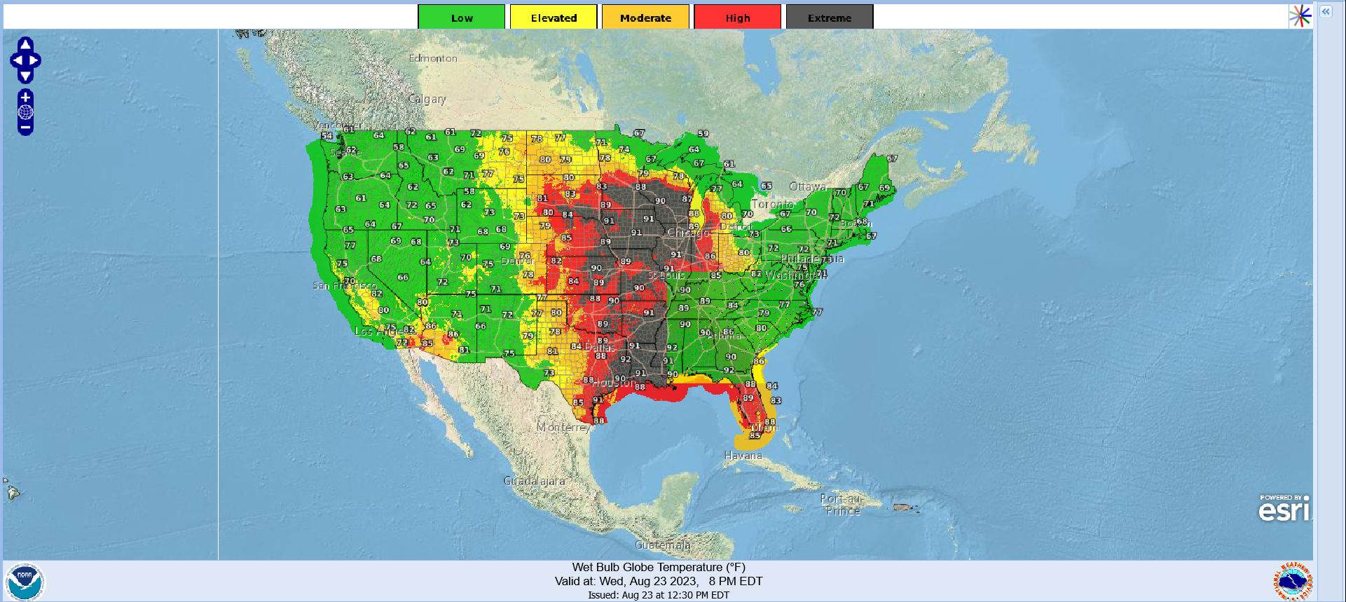
@0101010001110100 Thanks for the warning! FYI, wet bulb *globe* temperatures (which this map reports) aren't the same thing as wet bulb temperatures.
When you hear about certain wet bulb temperatures being unsurvivable, the assumption is one has already found shade and that is the wet bulb temperature out of direct sunlight. Or put another way, those fatality limits are if the wet bulb temperature in shade is over a threshold, then it's fatal.
Wet-bulb *globe* temperatures are slightly different: they're the weather forecast in direct sunlight. Moving to shade helps get you into a lower wet-bulb temperature.
So this is Bad, but it's not *quite* as catastrophic as it sounds like.
Is there a site that shows actual wet bulb risk forecasts globally based on accumulated weather data sets? I'm guessing this will become more and more relevant, especially around the equator.
@DarkThoughts
I haven't found one.
@0101010001110100
Windy.com is a great site and has a layer for forecasted WBT.
Link to the layer