Big Bear, CA

9 readers
26 users here now

This community is intended to be a community hub and resource center for Big Bear Lake, big Bear City, and the surrounding towns and cities.

founded 1 week ago
MODERATORS
1
22
submitted 8 hours ago* (last edited 8 hours ago) by [email protected] to c/bigbear


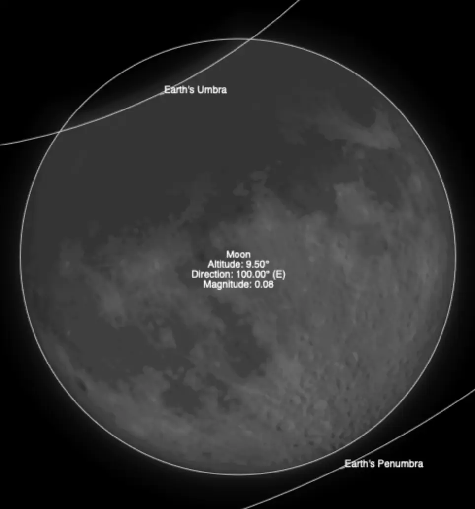
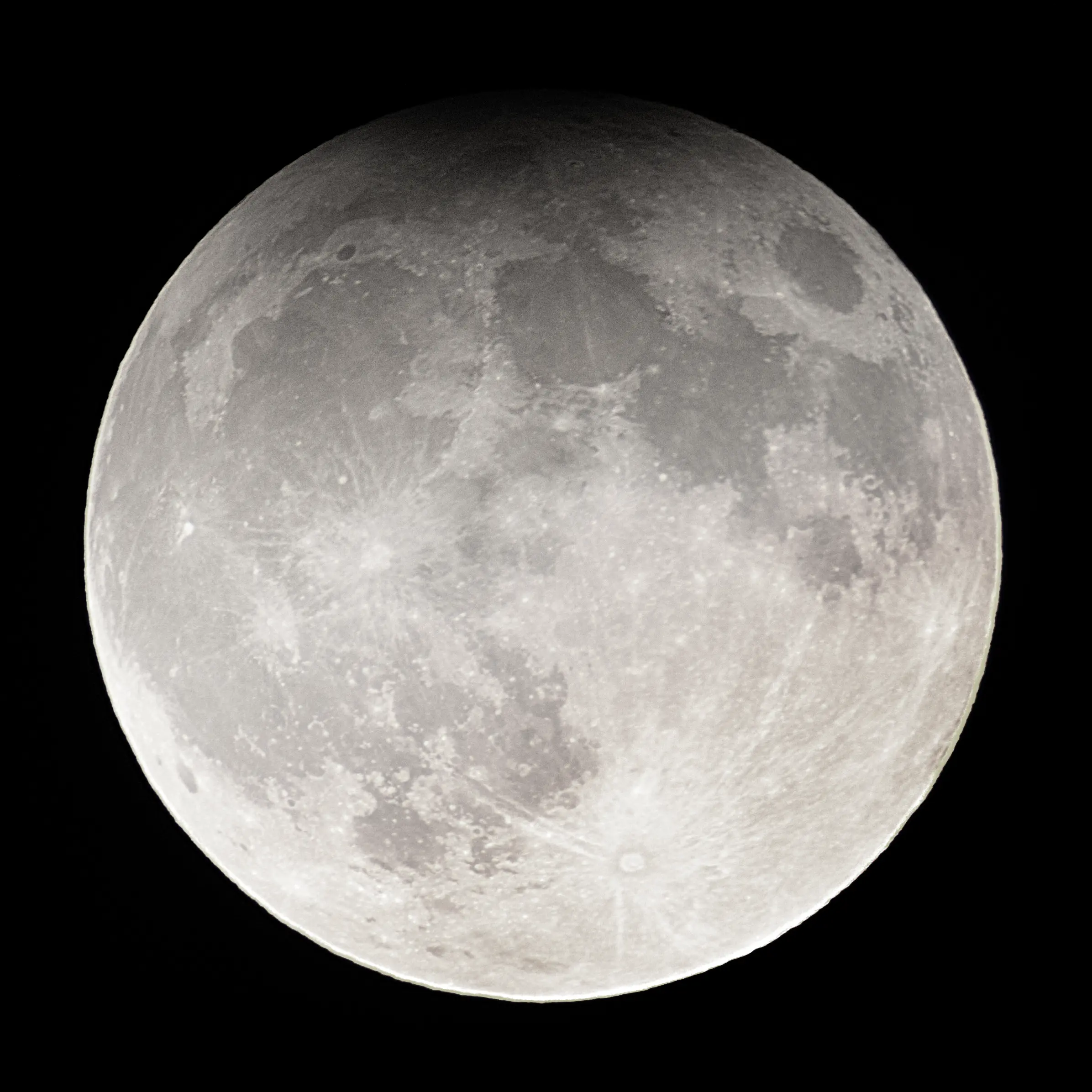
I wanted to share a picture of the moon last night, taken in MOONridge, just before 8:00 PM! This was not at the actual peak of the partial lunar eclipse, but rather 15 minutes or so afterwards.

This was a seasonal blue moon (the third full moon in a season that has four full moons), and a super moon (a time of year when the moon is closest to Earth).

2
35
submitted 5 days ago* (last edited 5 days ago) by [email protected] to c/bigbear


Here's a collection of Bears my cameras have caught over the last two months. Moonridge is absolutely full of them! I've been dying to post these somewhere, and this looks like the perfect place!


A Bear Visits me During the Line Fire at 7:30 PM
This is really early for them - it looked like sunset at 5PM due to the fire, and we think it threw this bear off his normal trash sniffing routine.
Dave Beary Visits My Home in Big Bear (we named the bear Dave Beary)
This guy is huge, and he's got some interesting markings on his face.
A Mama Bear and Her Cub
That is a very tiny bear cub. It's dangerous to see this, though, as I'm sure that Mama will react very defensively to being startled by us!
A Black Bear Chases Another Black Bear Through My Property
This was nuts. I was talking out on my deck, then came inside... seconds later, the cameras capture these two. I don't know if I spooked them, or if one spooked the other... but they BOOKED IT across my yard. Black Bears can run at speeds up to 35 mph.

3
16
submitted 6 days ago* (last edited 2 days ago) by LucidLethargy to c/bigbear


So these guys are a common occurrence on the hummingbird feeder, and they are well known for this behavior. I believe they are called Acorn Woodpeckers.

When I moved here earlier this year, it was absolutely hilarious to see this behavior. Previously, I've never seen anything but hummingbirds use their namesake feeders.

Edit: I updated the picture with a better resolution version! Original posted image is here:

4
7
Line Fire Resources (self.bigbear)
submitted 1 week ago* (last edited 5 days ago) by LucidLethargy to c/bigbear


I wanted to put together a hub of resources for the Line Fire here on Lemmy. I hope this helps anyone who might find it!

โš 

Sort by NEW to see the latest maps/updates!

๐Ÿ—ž

Line Fire Updates:

https://www.fire.ca.gov/incidents/2024/9/5/line-fire/updates
The latest updates from the county and state are funneled through here multiple times a day.

๐Ÿ—บ

Line Fire Maps:

The latest maps are being curated in the comments below multiple times a day, but the most up-to-date maps should always be the direct sources listed right here:

NOAA fire Map:
https://www.ospo.noaa.gov/products/land/hms.html#maps
The most reliable and frequently updated map that shows satellite readings of fire spread. This includes hotspots outside the perimeter, and a comprehensive smoke plume map.

Official Cal Fire Map:
https://www.fire.ca.gov/incidents/2024/9/5/line-fire
Shows live aircraft positions, and is updated a few times a day. Very reliable and helpful to review evacuation warnings/orders

3D Fire Map by Cal Fire
https://calfire-forestry.maps.arcgis.com/home/webscene/viewer.html?webscene=52683f25df174b0eb124dfb9a6831a98
Not updated more than once or twice a day, but a very cool map to inspect.

CleanAir Fire & Smoke Map
https://fire.airnow.gov/#10.64/34.2049/-116.9408
Updated more often than the Cal Fire map, and shows real-time air quality readings

Historical map of the Big Bear area
https://projects.capradio.org/california-fire-history/#10.76/34.1852/-116.9961/0/1
This is an extremely helpful tool for obtaining visual data of previous wildfire events. The linked map is centered on Big Bear and Arrowhead lake.

๐Ÿ“น

Line Fire Webcams

https://ops.alertcalifornia.org/cameras
This network of cameras can be used to easily and intuitively view the fire from multiple angles.

๐Ÿ“ป

Line Fire Radio

https://scancalifornia.com/live/goldmine/
This covers radio chatter from firefighters tackling the Line Fire.

๐Ÿ’ฌ

Community Resources

https://socalmountains.com/e107_plugins/forum/forum.php
A forum for locals that's been around since 2003

Local Images

https://www.flickr.com/photos/calfire/albums/72177720320272950/with/53989492937

Big Bear City trash pickup was halted on Tuesday, Wednesday and Thursday of this week. Water and Sewer services are all continuing without disruption. (and I haven't personally experienced any power disruptions yet.)