tropicalweather

358 readers
2 users here now

founded 1 year ago
MODERATORS
1
2
3
4


cross-posted from: https://lemmy.world/post/12751695

The following list of names will be used for named storms that form in the North Atlantic in 2024. This is the same list used in the 2018 season, with the exceptions of Francine and Milton, which replaced Florence and Michael, respectively.

  • Alberto
  • Beryl
  • Chris
  • Debby
  • Ernesto
  • Francine
  • Gordon
  • Helene
  • Isaac
  • Joyce
  • Kirk
  • Leslie
  • Milton
  • Nadine
  • Oscar
  • Patty
  • Rafael
  • Sara
  • Tony
  • Valerie
  • William
5


Only slight sarcasm.

I assume it'll die off once/if the weather cools down a bit in the worst case.

6


Please note that these posts do NOT necessarily reflect the official forecasts of the National Hurricane Center (NHC), and should not be interpreted as such. While tropical storms exist in the Atlantic, official NHC information is available at hurricanes.gov. Please refer to the NHC when making decisions, and heed the advisories and evacuation statements of your local National Weather Service Office and emergency management officials.

7


Please note that these posts do NOT necessarily reflect the official forecasts of the National Hurricane Center (NHC), and should not be interpreted as such. While tropical storms exist in the Atlantic, official NHC information is available at hurricanes.gov. Please refer to the NHC when making decisions, and heed the advisories and evacuation statements of your local National Weather Service Office and emergency management officials.

8


Please note that these posts do NOT necessarily reflect the official forecasts of the National Hurricane Center (NHC), and should not be interpreted as such. While tropical storms exist in the Atlantic, official NHC information is available at hurricanes.gov. Please refer to the NHC when making decisions, and heed the advisories and evacuation statements of your local National Weather Service Office and emergency management officials.

9


Please note that these posts do NOT necessarily reflect the official forecasts of the National Hurricane Center (NHC), and should not be interpreted as such. While tropical storms exist in the Atlantic, official NHC information is available at hurricanes.gov. Please refer to the NHC when making decisions, and heed the advisories and evacuation statements of your local National Weather Service Office and emergency management officials.

10


Please note that these posts do NOT necessarily reflect the official forecasts of the National Hurricane Center (NHC), and should not be interpreted as such. While tropical storms exist in the Atlantic, official NHC information is available at hurricanes.gov. Please refer to the NHC when making decisions, and heed the advisories and evacuation statements of your local National Weather Service Office and emergency management officials.

11


https://hurricanes.gov for up to date info

12
13
 
 
14
36
submitted 10 months ago* (last edited 10 months ago) by DocMcStuffin to c/tropicalweather


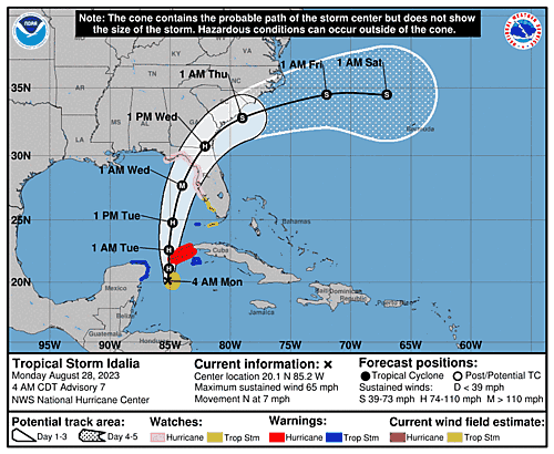
The eye of Hurricane Idalia came ashore near Keaton Beach, FL at 7:45 AM EDT (1145 UTC) [1]. Idalia landed as a Category 3 hurricane with maximum sustained winds near 125 mph (205 km/h), hurricane-force winds extending outward up to 25 miles (35 km) from the center, and tropical-storm-force winds extending outward up to 175 miles (280 km). [1, 2].

Idalia reached Category 4 intensity early this morning before weakening to a Cat 3 just before landfall. [3]

Resources

Live Coverage

News Coverage

15


Please note that these posts do NOT necessarily reflect the official forecasts of the National Hurricane Center (NHC), and should not be interpreted as such. While tropical storms exist in the Atlantic, official NHC information is available at hurricanes.gov. Please refer to the NHC when making decisions, and heed the advisories and evacuation statements of your local National Weather Service Office and emergency management officials.

16
17


Please note that these posts do NOT necessarily reflect the official forecasts of the National Hurricane Center (NHC), and should not be interpreted as such. While tropical storms exist in the Atlantic, official NHC information is available at hurricanes.gov. Please refer to the NHC when making decisions, and heed the advisories and evacuation statements of your local National Weather Service Office and emergency management officials.

18


Idalia is currently a strong tropical storm with wind speeds of 65 mph (55 kt). The storm is predicted to under go rapid intensification over the next 24 to 48 hours as it enters the very warm gulf waters. Peak sustained winds is predicted to be 115 mph (100 kt). This will be a Category 3 hurricane on the Saffir-Simpson scale.

The current predicted track has the storm slowly moving North with it picking up speed then shifting a bit Eastward. GEFS and ECMWF models show fairly strong agreement. The track has narrowed and shifted slightly to the East with landfall on Wednesday somewhere between Apalachee Bay and Tampa Bay.

In addition to the winds, storm surge and localized flash flooding is expected.

FORECAST POSITIONS AND MAX WINDS

INIT  28/0900Z 20.1N  85.2W   55 KT  65 MPH
 12H  28/1800Z 21.1N  85.1W   65 KT  75 MPH
 24H  29/0600Z 22.6N  85.1W   70 KT  80 MPH
 36H  29/1800Z 24.8N  84.8W   85 KT 100 MPH
 48H  30/0600Z 27.7N  84.0W  100 KT 115 MPH
 60H  30/1800Z 30.7N  82.1W   65 KT  75 MPH...INLAND
 72H  31/0600Z 32.8N  79.0W   55 KT  65 MPH...OVER WATER
 96H  01/0600Z 34.5N  72.0W   50 KT  60 MPH
120H  02/0600Z 34.5N  67.0W   50 KT  60 MPH

The National Hurricane Center has the latest track along with wind speeds and other graphics.

Note: Right now Lemmy is being weird and isn't letting me upload images.

19
 
 
20


Idalia's maximum intensity forecast has been raised slightly to a Cat 2 with predicted sustained winds of 100 mph (85 kts). The forecaster noted that the intensity forecast is somewhat challenging for this storm. See "Discussion Number 5" in the comments for details.

FORECAST POSITIONS AND MAX WINDS

INIT  27/2100Z 20.1N  85.5W   35 KT  40 MPH
 12H  28/0600Z 20.5N  85.3W   45 KT  50 MPH
 24H  28/1800Z 21.7N  85.0W   55 KT  65 MPH
 36H  29/0600Z 23.4N  84.9W   65 KT  75 MPH
 48H  29/1800Z 25.6N  84.5W   75 KT  85 MPH
 60H  30/0600Z 28.7N  83.7W   85 KT 100 MPH
 72H  30/1800Z 31.3N  81.9W   50 KT  60 MPH...INLAND
 96H  31/1800Z 34.5N  76.0W   50 KT  60 MPH...OVER WATER
120H  01/1800Z 35.0N  71.0W   55 KT  65 MPH

Original Post:

Current predictions from the National Hurricane Center have Tropical Storm Idalia (previously Tropical Depression 10) developing into a Cat 1 hurricane by Tuesday (the next 48 to 72 hours). It's expected to make landfall in Florida by Wednesday. The official forecast line has it hitting somewhere between Panama City (panhandle) and Tampa Bay (peninsula). The GFS and ECMWF models are mostly predicting landfall around Apalachee bay. These predictions, both the storm track and intensity, may change as the storm develops. When the storm enters the Gulf of Mexico on early Tuesday there will be very warm waters conducive to development, but it will also be under heavy windshear.

FORECAST POSITIONS AND MAX WINDS

INIT  27/0900Z 20.1N  86.8W   30 KT  35 MPH
 12H  27/1800Z 20.1N  86.5W   40 KT  45 MPH
 24H  28/0600Z 20.6N  86.3W   45 KT  50 MPH
 36H  28/1800Z 21.7N  86.3W   50 KT  60 MPH
 48H  29/0600Z 23.3N  86.2W   60 KT  70 MPH
 60H  29/1800Z 25.7N  85.7W   75 KT  85 MPH
 72H  30/0600Z 28.5N  84.7W   80 KT  90 MPH
 96H  31/0600Z 33.0N  81.2W   45 KT  50 MPH...INLAND
120H  01/0600Z 35.0N  75.5W   35 KT  40 MPH...OVER WATER

Resources

21
16
submitted 10 months ago* (last edited 10 months ago) by DocMcStuffin to c/tropicalweather


Tropical Depression Ten Discussion Number 1
NWS National Hurricane Center Miami FL AL102023
400 PM CDT Sat Aug 26 2023

The cloud pattern of the low pressure area located near the northeastern Yucatan Peninsula of Mexico has gradually become better organized today. Radar observations show a circulation has developed, although surface observations indicate that the western semicircle of this circulation is rather weak at this time. Given the increased organization, advisories are being initiated on Tropical Depression Ten. Surface synoptic observations suggest that the current intensity is around 25 kt.

The current motion estimate is nearly stationary. There is a weakness in the subtropical ridge to the north of the tropical cyclone, leaving the system in a region of very weak steering flow. The dynamical guidance indicates that the system will remain in weak steering currents for the next 24 to 36 hours, so very little motion is predicted during that period. After that time, a mid-level ridge begins to build to the east of the tropical cyclone. This should cause a generally northward motion in the next 2 to 3 days. Then, a gradual turn to the north-northeast is expected as the system moves along the northwestern periphery of the ridge. The official track forecast is a blend of the simple and corrected dynamical model consensus guidance.

The tropical cyclone will be moving over very warm waters with only moderate vertical wind shear anticipated during the next several days. Therefore, gradual strengthening is forecast. The official forecast is similar to the latest LGEM guidance and shows the system becoming a hurricane over the eastern Gulf of Mexico. Users are reminded that there is significant uncertainty in 3-4 day intensity predictions and are urged to monitor changes to future forecasts.

KEY MESSAGES:

  1. Heavy rainfall from Tropical Depression Ten is expected across the eastern Yucatan Peninsula and western Cuba. The heavy rainfall may produce areas of flash and urban flooding, as well as landslides, across western Cuba. The depression is forecast to become a tropical storm by Sunday, and tropical storm conditions are expected over portions of the Yucatan Peninsula where a Tropical Storm Warning is in effect. Tropical storm conditions are possible over portions of western Cuba within the Tropical Storm Watch area.

  2. The depression is forecast to strengthen during the next few days and could become a hurricane over the eastern Gulf of Mexico, bringing a potential of dangerous storm surge, heavy rainfall, and strong winds to portions of the west coast of Florida and the Florida Panhandle by the middle of next week. Heavy rainfall is also likely to spread into portions of the Southeast U.S. by mid to late next week. Although it is too soon to specify the exact location and magnitude of these impacts, residents in these areas should monitor updates to the forecast of this system and ensure that they have their hurricane plan in place.

FORECAST POSITIONS AND MAX WINDS

INIT  26/2100Z 21.1N  86.1W   25 KT  30 MPH
 12H  27/0600Z 21.0N  86.3W   30 KT  35 MPH
 24H  27/1800Z 20.9N  86.2W   35 KT  40 MPH
 36H  28/0600Z 20.8N  86.1W   40 KT  45 MPH
 48H  28/1800Z 22.0N  85.7W   45 KT  50 MPH
 60H  29/0600Z 24.0N  85.6W   50 KT  60 MPH
 72H  29/1800Z 26.3N  85.3W   65 KT  75 MPH
 96H  30/1800Z 31.5N  83.0W   45 KT  50 MPH...INLAND
120H  31/1800Z 35.0N  79.0W   30 KT  35 MPH...INLAND

$$
Forecaster Pasch


Original Post:

(800 AM EDT Sat Aug 26 2023) Northwestern Caribbean Sea and Eastern Gulf of Mexico (AL93): Shower and thunderstorm activity continues to show signs of organization in association with an area of low pressure located near the Yucatan Channel. Environmental conditions appear conducive for further development of this system, and a tropical depression is likely to form within the next day or two while it moves generally northward over the southeastern Gulf of Mexico. Interests in the Yucatan Peninsula of Mexico, western Cuba, and Florida should monitor the progress of this system.

  • Formation chance through 48 hours...high...70 percent.
  • Formation chance through 7 days...high...90 percent.

(1205 UTC Sat Aug 26 2023) Invest AL93: Shower and thunderstorm activity continues to show signs of organization in association with an area of low pressure (invest AL93) over the northwestern Caribbean Sea. Scattered moderate convection is noted within 120 nm in the N semicircle and 60 nm in the S semicircle of the low. Current winds are 20 kt with seas of around 5 ft. Environmental conditions appear conducive for further development of this system during the next several days, and a tropical depression is likely to form late this weekend or early next week while it moves generally northward over the eastern Gulf of Mexico. Interests in the Yucatan Peninsula of Mexico, western Cuba, and Florida should monitor the progress of this system. Please refer to the latest NHC Tropical Weather Outlook at www.hurricanes.gov for more details.

22
16
submitted 10 months ago* (last edited 10 months ago) by DocMcStuffin to c/tropicalweather


From the National Hurricane Center's Tropical Outlook Page

  1. Northwestern Caribbean Sea and eastern Gulf of Mexico: A broad area of low pressure over the northwestern Caribbean Sea near the northeastern coast of Honduras is producing disorganized shower and thunderstorm activity. Environmental conditions appear conducive for gradual development of this system during the next several days, and a tropical depression is likely to form late this weekend or early next week while moving generally northward over the northwestern Caribbean Sea and eastern Gulf of Mexico. Interests in the Yucatan Peninsula of Mexico, western Cuba, and Florida should monitor the progress of this system.
  • Formation chance through 48 hours...low...20 percent.
  • Formation chance through 7 days...high...70 percent.
23
 
 
24
 
 
25
5
Where is the European model? (self.tropicalweather)
submitted 11 months ago by kometes to c/tropicalweather


Several places I've looked haven't done a run since 20230627. What gives? Thanks.

view more: next ›